Science · Article
How Earthquakes Form and How Their Magnitude Is Measured
Published:
In brief
Earthquakes occur when stress built up along a fault is suddenly released as slipping rock, sending seismic waves through the crust. Scientists size that release using the moment magnitude scale, which has replaced the older Richter scale because it works accurately across the full range of earthquake sizes.
Earthquakes are a routine search topic worldwide, and interest spikes every time a notable tremor makes headlines. Two questions recur most often: what physically causes the ground to shake, and what the magnitude number reported afterward actually means. Both answers come from decades of seismology documented by agencies such as the U.S. Geological Survey (USGS) and research consortia like IRIS, the Incorporated Research Institutions for Seismology.
What causes an earthquake
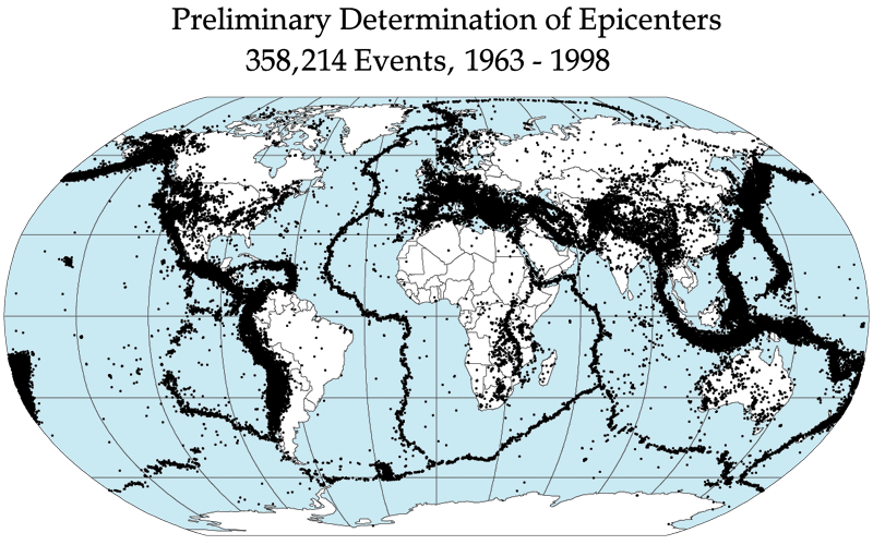
According to the USGS, an earthquake is caused by a sudden slip on a fault. Earth's crust is divided into large tectonic plates that are constantly, if slowly, moving. Where plates meet, friction causes their edges to stick together even as the plates keep pushing. The USGS cites California's Pacific and North American plates as an example: they grind past each other at roughly two inches per year along the San Andreas Fault, a boundary that runs more than 650 miles long and over 10 miles deep.
While a fault's edges remain stuck, the plates keep moving, which bends and stresses the rock on either side. That stored energy builds until it finally exceeds the friction holding the fault together. When the fault "unsticks," the stuck rock springs back into a less strained position in a sudden slip, and the energy that had been stored radiates outward in seismic waves, described by the USGS as spreading "like ripples on a pond."
Not every fault behaves the same way over time. The USGS notes that in some areas faults move through near-constant creep, releasing small amounts of strain in frequent minor shocks. Where creep is not constant, strain can accumulate for decades or centuries before releasing all at once, producing a larger earthquake.
Focus, epicenter and seismic waves
The point below the surface where an earthquake begins is called the hypocenter, or focus; the point on the surface directly above it is the epicenter, according to the USGS. From the hypocenter, two main types of waves travel outward: P waves, which compress and stretch rock in the direction they travel and arrive first at monitoring stations, and S waves, which move the ground side to side and arrive after P waves. The USGS explains that the time gap between the arrival of these two wave types at different seismograph stations lets scientists calculate how far away an earthquake occurred.
How magnitude is measured today
Magnitude describes the size of the earthquake at its source; an earthquake has a single magnitude value, according to the USGS. This is different from intensity, which measures shaking severity at a specific location and can vary widely depending on distance from the epicenter, depth, and local ground conditions — IRIS compares magnitude to a lightbulb's wattage and intensity to the brightness felt at different distances from that bulb.
The scale most familiar to the public, the Richter scale, was developed by seismologist Charles F. Richter in 1934, according to Michigan Technological University. It calculated magnitude from the amplitude of the largest wave recorded on a specific seismometer type, adjusted for distance from the earthquake. The USGS states that this approach does not accurately measure very large earthquakes: some events get underestimated, others overestimated.
Seismologists now primarily use the moment magnitude scale (Mw), which the USGS and Michigan Tech describe as preferred because it works accurately across the full range of earthquake sizes and is applicable globally. Moment magnitude is derived from a physical quantity called seismic moment, calculated as rigidity of the rock multiplied by the area of the fault that slipped multiplied by the distance the fault moved. That moment value, estimated from seismogram data and geological measurements, is then converted into the magnitude number reported publicly.
Why each whole number matters so much
Magnitude scales are logarithmic. The USGS and Michigan Tech both state that each increase of one whole number corresponds to a tenfold increase in the ground-motion amplitude recorded by seismic instruments, and roughly a 32-fold increase in energy released. Michigan Tech gives illustrative energy comparisons: a magnitude 1 earthquake releases energy roughly equivalent to 6 ounces of TNT, while a magnitude 8 earthquake releases energy equivalent to about 6 million tons of TNT.
| Scale | Introduced | Based on | Limitation noted by sources |
|---|---|---|---|
| Richter (local magnitude, ML) | 1934, Charles F. Richter | Amplitude of the largest wave on a specific seismometer, adjusted for distance | USGS: inaccurate for very large earthquakes |
| Moment magnitude (Mw) | Later 20th century, now standard | Seismic moment = rigidity × fault area × slip distance | USGS/Michigan Tech: preferred, accurate across all sizes, used globally |
Magnitude versus intensity
Because magnitude is a single number describing the energy released at the source, it does not by itself describe how strongly a particular town or building shook. Shaking severity at specific locations is instead described using intensity scales such as the Modified Mercalli Intensity Scale, which the USGS says is expressed in Roman numerals and depends on factors including distance from the epicenter, earthquake depth, and local geology.
Magnitude is the size of the earthquake. An earthquake has a single magnitude.
Questions
- What actually causes an earthquake?
- According to the USGS, an earthquake happens when stress built up along a fault — caused by slowly moving tectonic plates sticking at their edges — finally overcomes friction and the rock suddenly slips, releasing stored energy as seismic waves.
- What is the difference between the Richter scale and moment magnitude?
- The Richter scale, introduced by Charles F. Richter in the 1930s, calculates magnitude from seismic wave amplitude on a specific instrument type and becomes inaccurate for very large earthquakes, per the USGS. The moment magnitude scale (Mw), now preferred, is calculated from the physical seismic moment — rigidity, fault area and slip distance — and works accurately across all earthquake sizes.
- Does a magnitude 7 earthquake release exactly twice the energy of a magnitude 6?
- No. Both USGS and Michigan Tech state that each whole-number increase in magnitude corresponds to roughly a 32-fold increase in released energy, not a doubling.
- What is the difference between magnitude and intensity?
- Magnitude is a single value describing the energy released at an earthquake's source, while intensity describes how strongly shaking is felt at a specific location and varies by distance, depth and local geology, according to USGS and IRIS.
- What are the hypocenter and epicenter?
- The USGS defines the hypocenter (or focus) as the point below the surface where the earthquake begins, and the epicenter as the point on the surface directly above the hypocenter.
Sources
This piece was prepared with artificial intelligence and passed an automated source check before publication. If you see an error, ask for a correction. Request a correction or reply · How we make this
Related
ScienceNews
2026 Nobel Prize in Economics Goes to Robert Hall and Michael Woodford
The 2026 Nobel Prize in Economic Sciences has been awarded to American economists Robert E. Hall of Stanford University and Michael Woodford of Columbia University. The Royal Swedish Academy of Sciences honored them for building the "microeconomic foundations of macroeconomic stabilization," work now used by central banks worldwide to manage inflation, unemployment and economic shocks.
ScienceArticle
Africa's Turkana Rift: Why Scientists Say the Continent's Crust Is Thinner Than Thought
New seismic data show the crust along Kenya and Ethiopia's Turkana Rift has thinned to about 13 kilometers, less than half of what surrounding areas measure. Columbia University researchers say this means eastern Africa has entered "necking," an advanced, self-sustaining phase of continental breakup that could eventually produce a new ocean — though the process is expected to take several million more years.

ScienceNews
Margaret Hamilton, Apollo software pioneer who coined the term, dies at 90
Margaret Hamilton, who led the MIT team that wrote the onboard flight software for NASA's Apollo missions and is credited with coining the term "software engineering," died on September 30, 2026, at a hospital in Cambridge, Massachusetts. She was 90.
ScienceNews
USGS: Deep-Sea Sulfide Rocks Can Spontaneously Catch Fire in the Lab
A USGS-led team reports that iron-sulfide-rich rocks collected from the seafloor off the Oregon–California coast spontaneously combusted after being brought into a laboratory. The study, published in Scientific Reports, says the reaction poses a possible fire hazard for future deep-sea mining operations that has not been fully accounted for in current safety rules.