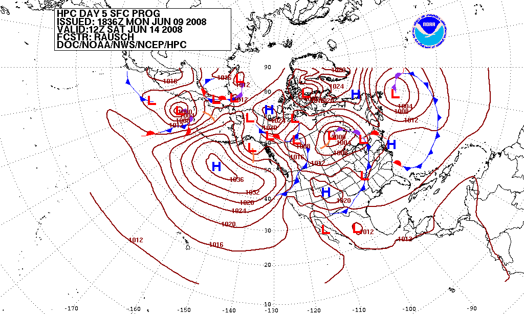
Modern weather forecasts are produced by feeding billions of daily observations into supercomputers that solve physics equations on a global grid, a process called numerical weather prediction. Forecasters then run the model many times with slightly varied starting conditions — an "ensemble" — to gauge how confident a prediction is. Because the atmosphere is chaotic, forecasts lose reliability after roughly 9 to 15 days, according to researchers and national weather agencies.
Every forecast shown on a phone app or television broadcast traces back to the same basic pipeline: observations go in, a supercomputer solves atmospheric equations, and a forecaster or algorithm turns the output into a prediction. The U.S. National Oceanic and Atmospheric Administration (NOAA) describes this process simply as weather prediction built on math — equations that represent the physical behavior of the atmosphere, solved repeatedly as time moves forward.
The six steps behind a forecast
Observations are collected worldwide — from weather balloons, satellites, buoys, radars, sensors on commercial aircraft and ships, river and coastal gauges, and ground stations — and converted into numerical values for temperature, pressure, moisture and wind, according to NOAA.
Data assimilation blends these fresh observations with the atmosphere's most recent short-range forecast. The European Centre for Medium-Range Weather Forecasts (ECMWF) says hundreds of millions of observations are filtered and combined with recent short-range forecasts every day through this statistical process, producing the best estimate of the atmosphere's current state.
A numerical model divides the globe (or a region) into a three-dimensional grid of points. NOAA notes that finer grids give more local detail but demand sharply more computing power — doubling the resolution in each direction roughly quadruples the calculations required for the same area.
Supercomputers solve the physics equations at every grid point for short time steps, then feed the result back in as the starting point for the next step. NOAA's machines, located in Virginia and Florida, perform about 2.8 quadrillion calculations per second; ECMWF's system uses more than one million processors delivering roughly 30 petaflops.
The model is run many times with slightly different starting conditions or physics settings, called an ensemble. NOAA says that when the runs agree, forecasters have higher confidence; when they diverge, that spread itself communicates uncertainty to the public.
Human forecasters and automated systems interpret the raw model output — adjusting for local terrain, known model biases, or recent observations — before issuing the public forecast, watch or warning.
Global vs. regional models
NOAA distinguishes between global models, which cover the entire planet at coarser resolution, and regional models, which cover a smaller area in finer detail. ECMWF runs its global model twice a day, at midnight and noon, with two additional intermediate runs that supply boundary conditions to member states' own regional models. The agency notes that a global model is necessary because weather disturbances on one side of the world can influence conditions elsewhere days later.
Why forecasts lose accuracy over time
The atmosphere is a chaotic system: tiny differences in starting conditions grow over time until the forecast diverges from reality. This principle, first identified by MIT meteorologist Edward Lorenz, is why no model — however powerful — can forecast indefinitely into the future.
A study led by Penn State researcher Fuqing Zhang tested the two leading global forecasting systems — ECMWF's model and the U.S. next-generation global prediction system — against real events, including a European cold surge and Chinese flooding, using near-perfect initial data. The team concluded that dependable day-to-day forecasts are achievable about 9 to 10 days ahead for the mid-latitudes, where most of the world's population lives, and that this could extend to roughly 14 to 15 days as data collection, algorithms and computing power improve.
We believe we have found that limit and on average, that it's about two weeks.
— Fuqing Zhang, Penn State University
NOAA's own technical guidance on model output gives a more conservative figure for raw, unprocessed grid forecasts, noting that models remain generally accurate out to about four days, after which run-to-run variation increases significantly — one reason ensembles and human forecasters remain part of the pipeline for the medium range.
Typical reliability by forecast range
Forecast range
What agencies say
Source
0–4 days
Model output is generally accurate; day-to-day detail is reliable
NOAA (JetStream)
4–10 days
Global models (e.g. ECMWF, U.S. systems) remain dependable for the mid-latitudes with ensembles used to show uncertainty
Penn State study; NOAA
Up to 16 days
NOAA's global numerical model extends forecasts this far, though confidence declines sharply with time
NOAA
~14–15 days (theoretical limit)
Considered close to the maximum possible skill for day-to-day prediction, even with a perfect model and perfect data
Penn State study / Lorenz chaos theory
What's next for forecasting technology
ECMWF says future gains depend on finer-resolution ensemble forecasts, better representation of Earth system processes (atmosphere, land and ocean together), and improved assimilation of weather observations — all of which require more computing power. The centre's Scalability Programme is preparing for exascale computing (a billion billion calculations per second) and is also exploring machine-learning techniques as part of its forecasting systems, according to its own fact sheet.
Questions
How far ahead can weather be reliably forecast?
National agencies and researchers generally agree that forecasts are most reliable out to about 4 days for fine detail, remain dependable to roughly 9–10 days for day-to-day conditions in the mid-latitudes, and lose most practical value beyond about 14–15 days, which chaos-theory research identifies as close to the physical limit of predictability, per a Penn State-led study.
What is an ensemble forecast?
It is a set of multiple runs of the same weather model, each started with slightly different initial conditions or physics settings; NOAA says that when the runs agree closely, forecasters have higher confidence, and when they diverge, that spread is used to communicate uncertainty.
Why do different weather apps sometimes disagree?
Apps often draw on different underlying models (such as the U.S. global model or ECMWF's model) or apply different post-processing, and NOAA notes no single model is accurate 100% of the time, which is why agencies rely on multiple models and ensembles rather than one source.
What is data assimilation?
It is the statistical process of combining new observations with the atmosphere's recent short-range forecast to produce the best estimate of current conditions; ECMWF says hundreds of millions of observations are processed this way every day.
Why can't computers just forecast weather perfectly with more power?
Because the atmosphere is a chaotic system, small errors in initial observations grow over time regardless of computing power — a limit identified by meteorologist Edward Lorenz and estimated at roughly two weeks even with near-perfect data, according to the Penn State-led study.
This piece was prepared with artificial intelligence and passed an automated source check before publication. If you see an error, ask for a correction. Request a correction or reply · How we make this
Brazil's Amazonas state recorded 1,380 forest fire hotspots between October 1 and 10, 2026, a 271% rise from the 372 hotspots counted in the same period of 2025. Governor Roberto Cidade declared a state emergency, and the federal government recognized emergency status in 36 municipalities on October 10, releasing aircraft, firefighters and funds to fight the blazes.
A historically strong El Niño is the dominant signal behind winter 2026-2027, with NOAA's Climate Prediction Center giving it up to an 83% chance of record strength. Forecasters in the US and Europe expect a milder, wetter and stormier season overall, though short cold spells remain possible. Below is what agencies say so far, plus official steps for winterizing a home and car.
Overnight storms into October 10, 2026 triggered flooding, overflowing streams and landslides across southern Italy, with the worst damage reported on the Sicilian island of Lipari and in Calabria's Reggio area. Italy's Civil Protection Department had issued an orange weather alert for Sicily and parts of Calabria, Puglia and Campania, as mud and debris swept into homes, streets and the sea.
El Niño is a recurring warming of surface waters in the central and eastern Pacific Ocean that disrupts global weather by shifting rainfall, drought and storm patterns far beyond the tropics. The event declared by NOAA in June 2026 has intensified into one of the strongest on record, with forecasters warning its effects will extend into early 2027.